Monitoring and traceability are two of the biggest challenges to achieve the zero-deforestation commitments within the palm oil supply chain. Thanks to the technology provided by Satelligence, the support provided by GIZ, the brains & boots on-the-ground of Solidaridad, a growing number of industry players, traders and palm oil processing companies in Colombia are now using real-time satellite data combined with ground data to monitor deforestation in the last mile of the supply chain.
Moving from high level zero deforestation commitments to collective action on the ground
Colombia is the fourth producer of palm oil in the world and a key provider of the European industry. Colombia is the biggest producer in Latin America (32% of total production in the Western Hemisphere).
In November 2017, Colombia was the first country to sign a national zero-deforestation declaration for the palm oil sector. Under this agreement, domestic palm oil companies and buyers make comprehensive analyses of the deforestation risks in their supply chain, elaborate improvement plans and improve traceability and monitoring mechanisms.
At international level, the recent adoption of the Supply Chain Due Diligence Act by the German Federal Parliament in 2021 and the publication of the EU´s Directive of the European Parliament and of the Council on Corporate Sustainability Due Diligence) in 2022 will set binding standards on deforestation for large companies and the due diligence of their supply chains.
In light of the increasing importance given by global companies, financial institutions and EU governments to the traceability of products associated with the loss of forests and biodiversity, it has become of vital importance to elaborate more comprehensive characterizations of the full supply chain, including the (independent) producers beyond the processing mill, the so-called last mile. Ground data and satellite data are crucial inputs for the definition of priorities and the formulation of zero-deforestation supply policies by international companies, financial institutions and governments towards the large base of smallholder producers.
Currently, processing companies are able to track the source of their palm oil up to the level of processing mill, but they are unable to identify the quantities and origin of the processed fruit of all their (independent) fresh fruit bunches providers at farm level.
The information restrictions primarily exist with full georeferencing (identification of polygons), which is limited available for the smallholder suppliers of fresh fruit bunches (FFB) in Colombia.

To encourage the efforts of the Colombian palm oil sector to become a zero-deforestation origin, and with the support of GIZ and FEDEPALMA, Solidaridad is currently implementing the Sustainable Origin Accelerator for Palm oil (SOAPS) program.
An initiative to accelerate the sustainable transformation of the global palm oil supply chain and to achieve fully traceable, sustainable, and zero deforestation supply chains from the field to the shelf in the departments of Bolivar, Magdalena, Casanare and Meta.
Under the SOAPS program the criteria of global corporate zero-deforestation policies (NDPE commitments) are benchmarked with the criteria of the local Colombian Zero-Deforestation Agreement.
In order to monitor the progress and the commitments made in the zero-deforestation agreements, satellite-based and digital information sources are made available to the program partners.
Parallel to the SOAPS program and with the help of the Dutch Ministry of Foreign Affairs, Solidaridad has started in 2021 monitoring the Catatumbo area in the department of Norte de Santander. These complementary efforts enable the palm oil sector in Colombia to monitor a total of 120.000 hectares of deforestation and Land Use Change (LUC).

Combining satellite and ground data for better results
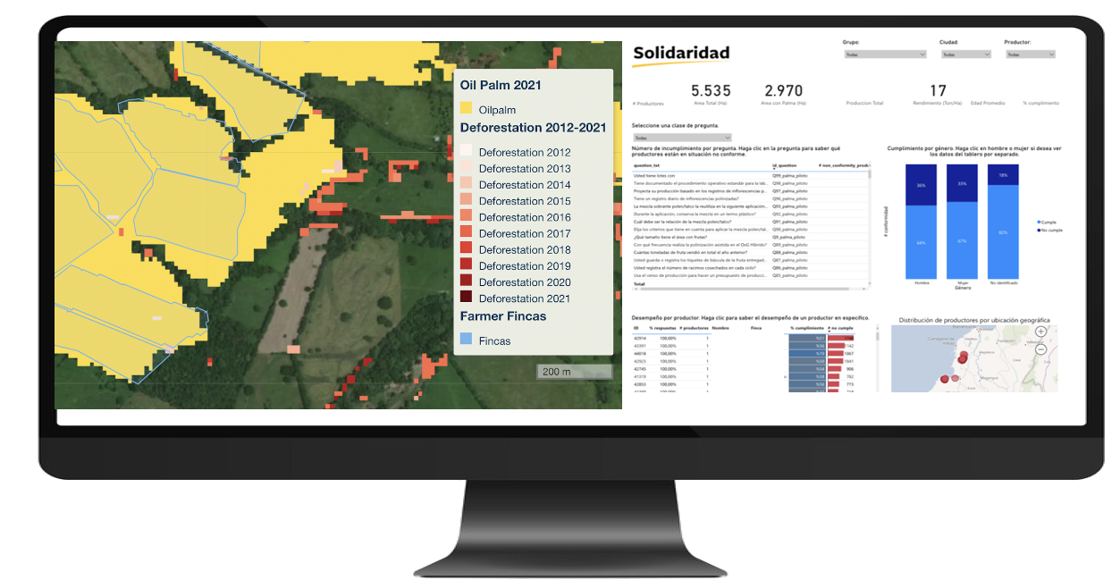
At the core of this novel approach in Colombia is the integration of satellite-based data provided by Satelligence and the ground data collected by Solidaridad through its suite of digital solutions.
Satelligence provides images that can be taken even through clouds, using the ESA and NASA satellite information. Combined with local on-the-ground intelligence and machine learning, it creates a comprehensive picture of forests and land use in the key palm oil production areas.
Through real-time monitoring, changes on vegetation cover can be detected, creating timely alerts and enable supply chain stakeholder to assess and mitigate the situation.
This is particularly useful in high-risk areas of special interest to traders and industry players. This information will be complemented with data on the management of High Conservation Value areas in and around palm oil plantations.
HCV assessments are carried out by licensed HCV assessors who are monitored by the Assessor Licensing Scheme (ALS) on their performance through desk-based evaluation of their HCV or HCV-HCSA assessment reports.
This innovative collaboration between Solidaridad and Satelligence enables the sector to have better identification and understanding of challenges and risks. This is crucial to channel resources and efforts towards it is most needed, leading to more effective interventions that support palm oil producers to live up to zero-deforestation commitments, within and close to their plantations.
Key numbers at a glance:
- To monitor 2.100 producers, who manage 45.200 hectares, plus another 216,800 hectares in the area.
- 262,000 hectares in total, located in the municipalities of Maria la Baja, San Juan de Nepomuceno, San Jacinto, San Pablo, (Bolivar); Villanueva (Casanare); Abrego, Convencion, El Carmen, El Tara, Harare, La Playa, Ocaña, San Calixto, Sardinata, Teorama and Tibu (Norte de Santander) in Colombia.
- Elaboration of Land Use Baseline, a Historical Forest Loss and Land Use Change assessment, and a Forest Loss monitoring.
