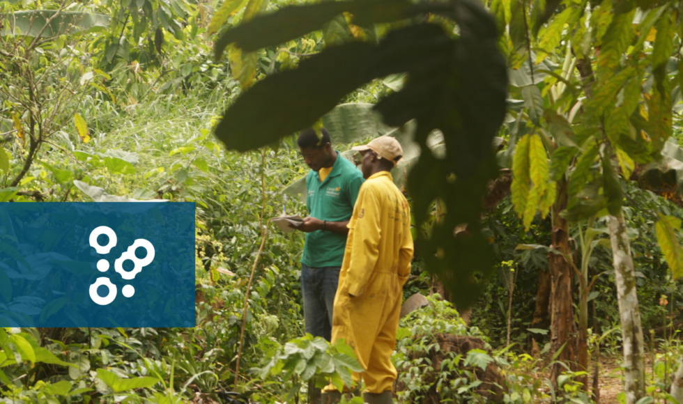
When Daniel opens his tablet, the forest loss that he needs to verify pops up on the screen. The demarcation between the reserve and the oil palm plantation is clearly visible on the map. Earlier that week he received an alert that part of the forest was cleared. After finishing with his regular farm visits, he quickly makes his way to the indicated location.
Daniel is quite familiar with the Kijogolo Forest Reserve in the south of Uganda. He knows that you can find yourself in a protected area without being aware of it. Boundaries and demarcations are often not clear or visible and a farmer will tell you where his or her land ends, but not where the protected forest begins.
“Before, our field teams could only guess if planting new oil palm happened in or outside the reserve. But since we can bring satellite data to the field, our evidence is much more credible”.

How to turn your commitments into results
Protecting forest and putting a halt to deforestation in Africa’s rural landscapes such as Kijogolo is absolutely not an easy task. Population growth, lack of resources for authorities to patrol and local incentives to plant new crops, are increasing pressure on forest reserves.
At Satelligence we notice that many private sector actors pledge support for tackling deforestation in their supply chain. However, forest loss continues to increase. Especially in sub-tropical and tropical regions.
Satellite technology can be an important tool to help companies and organizations translate commitments into results. It raises the credibility of your evidence, starts conversations with local communities and sends field teams to the right places. But how do you make sure the information from your dashboard gets implemented on the ground?
1 – Bring data that is relevant
For companies, the first step in reducing supply chain risk is talking to your suppliers. But when you engage, your information such as the location and timing of deforestation has to be relevant. That means your underlying data needs to be reliable and up to date with what is happening on the ground.
In cocoa, for example, we created a dynamic map that shows the entire cocoa distribution in West Africa. It gives you not only answers to the question of where cocoa is growing, but also where deforestation risk can be linked to cocoa or rather to other drivers.
This is important, because not all deforestation picked up is of immediate interest. In order to do something meaningful with the detected changes you need alerts that are relevant for you. That’s why at Satelligence we developed an alert prioritisation framework to convert confirmed changes into actionable alerts relevant for you, your suppliers, buyers and investees. You can find more about that in our blog here.
2 – Know where you are going
Receiving information about high risk deforestation areas, in the comfort of your office alone is not stopping deforestation from happening. How the information is used, is what makes the difference. You now know where exactly to send out your field team, the responsible government agency, or a local NGO to verify and engage.
In 2019 we found that there are multiple drivers of deforestation other than cocoa in Ghana. Which means that making an impact in the landscape requires reaching out to various stakeholders. We also found that risky clearing of forest outside reserves is often overlooked. Yet other areas even showed an increase in forest cover. This is useful information for field teams on the ground. It makes a big difference in the approach if the main driver in your sourcing area is cocoa, community encroachment for annual crop production, mining, or selective logging for timber.
Deforestation is a global issue, and a local challenge. What works in one part of the world doesn’t necessarily work somewhere else. Interventions and interaction on the ground are necessary to verify alerts, to get feedback on what is happening and whom to engage with. Only then you can find the right solutions.
The second step to close the gap therefore lies in your interaction with the reality in the field. You need to go there and check what is going on. Verify what is behind the alert and what can be done about it.
3 – Use your logistics efficiently
Wise management and protection of forests is actually about logistics. Forest verifications, law enforcement and community meetings, they all require resources. So you better use them wisely.
Forest protection units often have little staff, or paid guards, insufficient means of transportation while covering long distances of hardly accessible forest. Without satellite technology you waste a lot of time finding out where to go and whom to talk to.
The large area, in our example, has only 4 staff members and 9 paid guards, just 1 boat and 3 motorbikes. And often no fuel. But after using satellite information, their field teams are 10x more efficient. They know where to go, and where not to, and bring along information that can be checked and used as a conservation starter with local farmers and other stakeholders.
Another example is that, for companies part of the Cocoa and Forest Initiative, mapping farms is mandatory. GPS mapping offers great potential as a way to gather accurate data. Particularly in remote rural environments. Still, the mapping of about 6 million smallholder cocoa farmers is not an easy task. Farms are often remotely located at long distances from each other. Tropical showers make local roads inaccessible and dense tree cover may block your GPS signal. When farms are finally mapped, it becomes even more difficult if you need to go there every year to see if any planting has expanded into forests.
But what if you combine satellite-based intelligence with existing cocoa farm data?
At Satelligence we provide results showing deforestation patterns as well as hotspots where the deforestation risk is highest. This way farms and forest reserves are being tracked simultaneously while you can guide your field teams to most urgent alerts.
IT’S NOT NECESSARILY BAD NEWS
For many companies it may be intuitive to keep deforestation detected a secret, but mistakes can happen everywhere. It actually makes a better story to demonstrate continuous improvement. That shows buyers, investors, and other stakeholders that you are on top of things and proactive. So if you want to demonstrate long term solutions, transparency is key.
In Uganda for example, development of the palm oil sector typically faces negative media publicity. Basically, it is seen as a scapegoat for deforestation in the country. Powered by the European Space Agency’s EO4SD programme, we have set up a mapping and monitoring system to support sustainable development with independent, science-based information.
The system tracks vegetation changes on a daily basis, with reports that are shared with involved ground teams of forest authorities and community members, every other week. The resulting alerts are followed up by these ground teams for further investigation in the field. This not only allows for better accountability for guards who are paid to protect the forest, it also allows projects to be more transparent and present independent evidence on the work they are doing.
This also applies to the cocoa sector.
Local landscape projects help to establish and organise local community and governance structures, which is the ideal basis for better tackling deforestation on the ground. Connecting satellite-based monitoring can dramatically increase efficiency and accountability: to better detect – investigate – act – document and thereby reduce deforestation.

Closing The Gap
Satellite technology is often framed as the solution for deforestation. But don’t forget it’s just a tool. Thanks to satellite based alerts, Daniel now knows illegal oil palm planting in the reserve is limited to a minor part of the north western corner. The majority of encroachment by local villagers is for charcoal production, rice fields and watermelon production in other areas and has the priority of his field teams at the moment.
If you take these three extra steps after you receive a deforestation alert we can turn our commitments into reality. Just as Daniel says:
“Satellite monitoring is just the start. You still have to get out of your office to stop deforestation”.
By Femke Dekker