
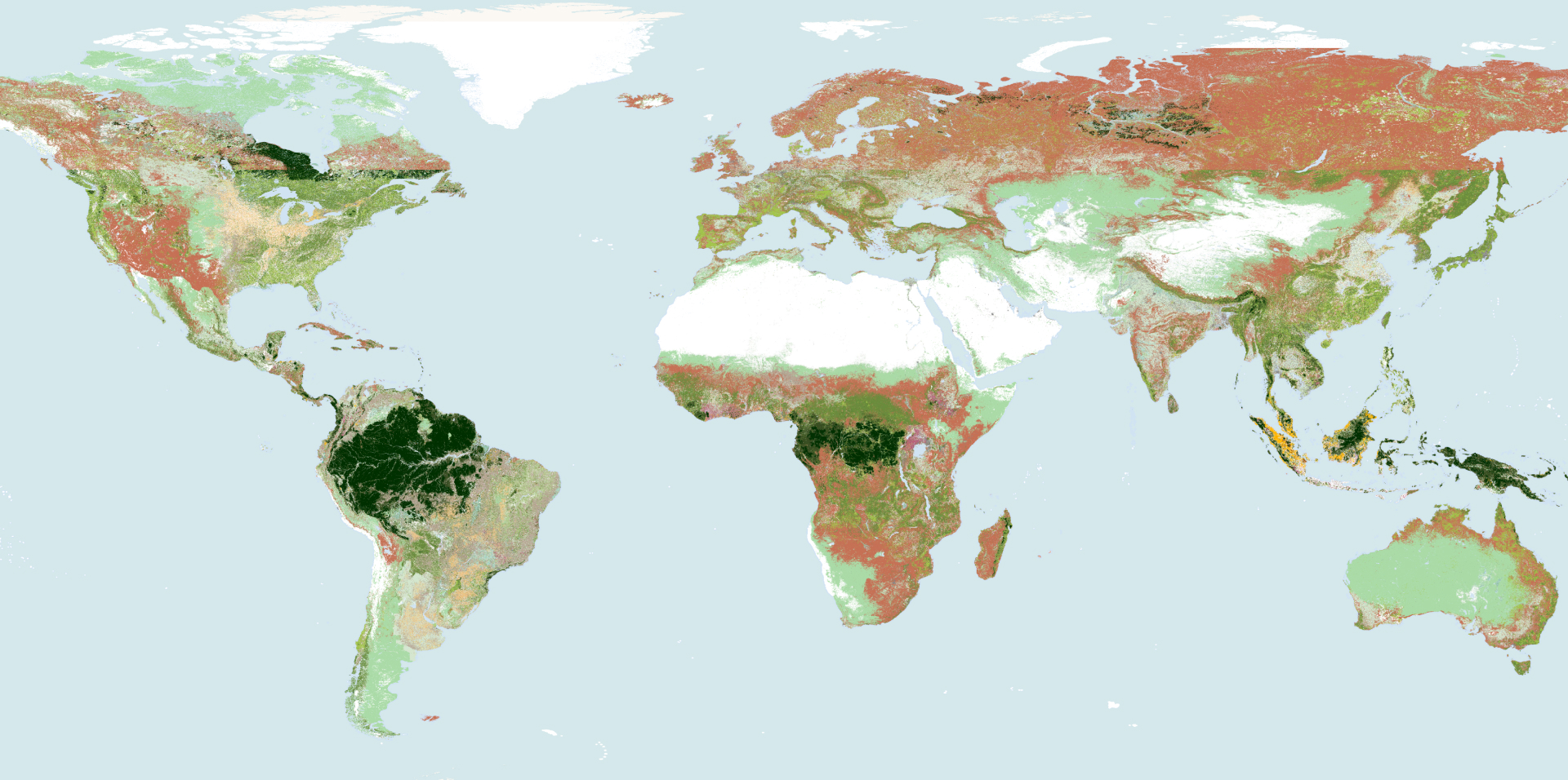
A nature and commodity baseline helps companies assess EUDR deforestation risk by providing a consistent reference for historical land cover and changes at plot level. By mapping forest and commodity crops over time, it can help companies identify potential deforestation, investigate sourcing risks, and document the evidence supporting their due diligence decisions. A baseline supports EUDR compliance processes but does not independently establish compliance.
For sustainability, procurement, and compliance teams, the pain point is consistency. Without an agreed, high‑quality reference layer, different datasets can tell different stories about the same plots, making it harder to classify deforestation risk, explain sourcing decisions, or defend due diligence statements under EUDR.
How does a baseline support EUDR deforestation risk assessments?
Under EUDR, companies need to show that production plots linked to EU‑bound commodities were not associated with deforestation after the cut‑off date. A credible nature and commodity baseline provides the forest reference against which supplier polygons are assessed, so that deforestation risk is evaluated in a consistent, documented way.
In Satelligence’s own forest‑baseline accuracy assessment, the forest baseline scored between 81% and 93% overall accuracy across South America, Africa and Asia when mapping forest versus non‑forest at 10‑metre resolution. These results are documented in the Satelligence forest-baseline accuracy assessment and relate to a specific methodology, sampling design and set of reference labels.
For Côte d’Ivoire, the same assessment reported 93.3% overall accuracy for Satelligence’s forest baseline, compared with 77.1% for the JRC EUDR v2 global forest layer and 77.5% for Côte d’Ivoire’s national land‑cover map, all validated against the same reference labels.
A separate independent study by the Alliance of Bioversity International and CIAT with the World Cocoa Foundation reported 87% precision for Satelligence’s forest classification in Côte d’Ivoire, as documented in CIAT & WCF (2025).
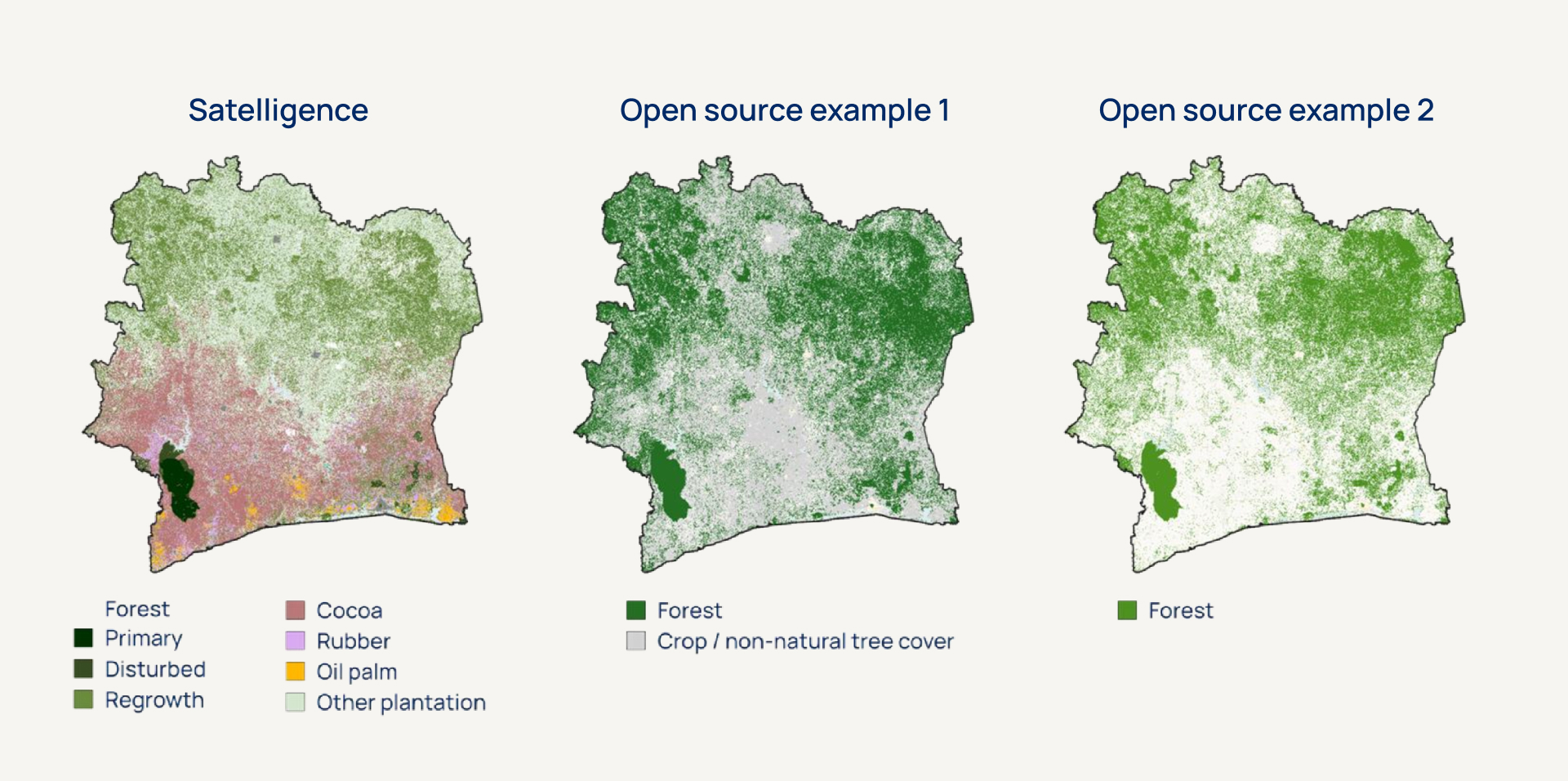
Precision and overall accuracy are different metrics, but together they help companies understand how reliably forest is identified in complex landscapes.
In practice, EUDR deforestation risk assessments typically:
- Combine plot‑level geolocation (points or polygons) with a forest baseline for the relevant cut‑off year.
- Analyse land‑cover change before and after that date to flag potential deforestation events.
- Use those results as one input into a broader due diligence and risk‑mitigation process.
What makes a baseline reliable?
The reliability of a nature and commodity baseline depends on its:
- classification accuracy,
- geographic coverage,
- historical data,
- transparency and,
- suitability for the sourcing landscape
Complex agricultural landscapes, distinguishing perennial commodity crops from natural forest can be challenging.
Classification errors can affect how companies interpret land‑cover change and assess deforestation risk, for example by mistaking the clearing of long‑established cocoa for recent forest loss, or by failing to detect expansion into previously unconverted forest.
Independent validation can help companies understand how well a dataset distinguishes natural forest from commodity crops and where classification limitations may affect risk assessments.
Comparative accuracy figures should be interpreted in the context of the assessment methodology, reference data and geographic area tested.
Satelligence’s Harmonised Nature & Commodity Baseline (HNCB) combines field‑scale forest mapping at 10‑metre resolution with commodity maps for crops such as cocoa, coffee, palm oil and rubber.
It integrates more than 80 peer‑reviewed global, regional and national datasets with curated open data and on‑the‑ground validation. This convergence‑of‑evidence approach is designed to reduce the limitations of individual datasets and to make it easier for companies to explain how baseline classifications were derived.
How do you evaluate a baseline for EUDR?
When you assess a baseline for EUDR, the key question is whether it provides a defensible foundation for real‑world sourcing decisions. Practical evaluation criteria include:
✓Accuracy and independent validation
Look for documented accuracy metrics (such as overall accuracy, class‑specific precision) and, independent assessments like the CIAT & WCF (2025) evaluation. These help you understand how reliable the baseline is for forest versus non‑forest.
✓Ability to distinguish forest from commodity crops
Check whether the baseline can separate natural forest from perennial crops like cocoa, coffee, rubber and oil palm in your sourcing regions, as this distinction directly affects which plots are flagged as potentially non‑compliant
✓Geographic coverage of sourcing regions
Confirm that the baseline covers all relevant countries and landscapes where your suppliers operate, so that the same standard of evidence can be applied across your portfolio.
✓Historical land‑cover data & EUDR cut‑off
Ensure the baseline includes forest information for the EUDR cut‑off date and subsequent years, enabling you to detect land‑use change over time and link it to specific sourcing periods.
✓Transparent methodology & documented limitations
Prefer providers that publish their methodology, input datasets and known limitations, so that you can explain your data choices to auditors, NCAs and internal stakeholders.
✓Suitability for relevant commodities & supply chains
Assess whether the baseline and associated commodity maps are appropriate for the crops, farm sizes and production systems in your supply chain, from smallholders to larger estates.
How can one baseline support broader Nature Intelligence?
A shared, harmonised baseline can provide a consistent geospatial foundation for deforestation risk and monitoring, land‑use change emissions estimates and wider nature‑related assessments. Each application may also require additional datasets and its own methodology.
Working from a single, well‑documented baseline helps sustainability, procurement and risk teams avoid contradictory maps and metrics when they connect EUDR due diligence, Scope 3 land‑use change emissions and broader nature‑related risk indicators. Instead of reconciling conflicting datasets, teams can focus on interpreting one coherent view of the landscape and agreeing how to act on it.
Key takeaway
The Harmonised Nature & Commodity Baseline (HNCB) provides an important foundation for consistent, evidence‑led EUDR risk assessments. Combined with accurate supplier geolocation, appropriate due diligence procedures, and documented risk mitigation where required, it can help companies investigate potential deforestation, explain sourcing decisions and manage nature‑related risks across their supply chains.
To understand how a harmonised baseline could support your EUDR due diligence and wider sustainability goals, talk to an expert on our team.