Geospatial & Deforestation Monitoring
Satelligence utilizes a combination of radar and optical satellite imagery, including data from Sentinel-1, Sentinel-2, and Landsat missions, to monitor deforestation and land-use changes.
How do you distinguish between actual deforestation and seasonal changes (e.g., rubber wintering)?
By analyzing multi-temporal satellite data, Satelligence differentiates between permanent deforestation and temporary canopy changes, such as those occurring during rubber tree wintering.
How does Satelligence define “forest” and what methodology is used for detection?
Satelligence defines forests based on canopy cover and land-use classifications, aligning with EUDR deadline 2026. Their methodology includes integrating satellite data with ground-truthing to accurately map forested areas.
Can clients access high-resolution satellite data, and if so, under what conditions?
Yes, Satelligence provides access to high-resolution satellite imagery, including data from programs like NICFI, to enhance monitoring capabilities. Access conditions depend on client agreements and specific project requirements.
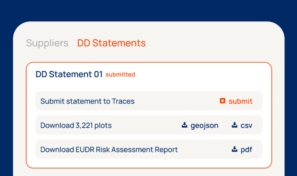
What is the data size limit for files on the Satelligence platform and Traces?
TRACES limits DDS files to 25MB and a maximum of 10,000 plots. Satelligence’s platform is optimized to stay within these constraints and support multiple submissions for full harvest coverage.
What file formats are supported for uploads/downloads?
Satelligence supports standard geospatial data formats such as GeoJSON, Shapefile, and CSV for data uploads and downloads.
Can Satelligence handle EUDR’s 25MB per document limit?
Yes, Satelligence ensures outputs stay within the 25MB TRACES limit and supports up to 10,000 plots per DDS. For larger datasets, we assist in managing submissions across multiple DDSs as needed.
What should we do when different sources of truth conflict (e.g., local plot data vs. satellite evidence)?
Satelligence recommends cross-validating data sources and provides tools to reconcile discrepancies between ground data and satellite observations.
Where does Satelligence source its palm oil supply chain data from?
Satelligence combines satellite imagery with supply chain information from clients, public databases, and partnerships to map and monitor palm oil supply chains.
How does Satelligence support origin identification in complex or opaque supply chains?
Satelligence provides both plot-level and jurisdictional deforestation risk data—aligned with the EU’s upcoming benchmarking system—to help clients assess risk beyond the plot and ensure robust DDS submissions, even in high-risk or mixed-origin supply chains.
Who owns the plot data collected? Who should pay for mapping and certification?
Ownership of plot data typically resides with the data provider, often the client. Costs for mapping and certification are determined through client agreements and project scopes.
Satelligence provides APIs that allow clients to integrate deforestation monitoring data into their internal systems, enhancing traceability and compliance workflows.
What’s included in Satelligence’s SLA (Service Level Agreement)?
While specific SLA details are client-specific, they generally outline service availability, data delivery timelines, support response times, and performance metrics.
What kind of technical support does Satelligence provide—and what’s out of scope?
Satelligence offers technical support for its platform and services, including assistance with data interpretation and system integration. Support scope is defined in client agreements.
What kind of information should we ask suppliers for legal compliance and risk evaluation?
Suppliers should provide geolocation data, and evidence of legal sourcing in compliance with EUDR deadline 2026.
Will certified volumes reduce the effort required to comply with EUDR?
While certification can support compliance, EUDR 2026 still requires traceability and due diligence documentation. Certified volumes may streamline risk assessment but do not replace legal obligations.
Can Satelligence act as an authorized representative under EUDR 2026?
Yes, Satelligence can act as an authorized representative to submit Due Diligence Statements (DDS) on behalf of companies, including subsidiaries. This simplifies compliance process and reduces administrative burden for larger organizations.
Traders must ensure the products they sell are covered by a DDS and are EUDR-compliant. Unlike operators, they are not responsible for the initial submission but must verify documentation before trading.
How does Satelligence address the ‘legality’ aspect of EUDR due diligence?
Satelligence supports clients in verifying legal sourcing by providing data on land use, deforestation, and supply chain transparency, all of which contribute to meeting EUDR due diligence requirements.
Does Satelligence collaborate with legal partners?
Even though the responsibility for legal compliance always remains with each respective company, Satelligence goes to great lengths to offer a product that is in line with the relevant legal requirements.
We therefore work together with the law firm GvW Graf von Westphalen (GvW) to support us with their legal assessment of some aspects of the tool, which helps us in further developing our product. Additionally, we can connect our clients with GvW in case they require further legal guidance. They can thereby be sure to have a highly specialised competent advisor team at their side that has been working on the EUDR since the very beginning.
This partnership underlines our commitment to supporting our clients with both technical and legal confidence in their EUDR implementation efforts.
To comply with the EUDR, traders and operators must follow a structured due diligence process outlined in the EUDR Guidance document before placing or exporting covered commodities (like soy, palm oil, coffee, cocoa, cattle, wood, and rubber) on the EU market.