Effortless EUDR compliance with the most trusted deforestation
risk data
As the market leader for deforestation risk data, we set the standard for accuracy, reliability, and seamless decision-making—giving you the confidence to meet EUDR compliance without uncertainty.


Transparent and certified
Certified, science-backed, and fully audit-ready, our data upholds the highest integrity standards. Developed with leading European institutions, it undergoes rigorous review and is backed by top-tier security certifications.

Accurate and reliable
The most accurate deforestation risk data available—far surpassing open data and other solutions—empowering you to make informed, risk-free decisions with confidence.

Trusted and proven
Europe’s largest and most connected EUDR provider, directly engaged in EU pilots and trusted by Competent Authorities, producer governments, and leading research institutes.


Your end-to-end solution for
EUDR compliance
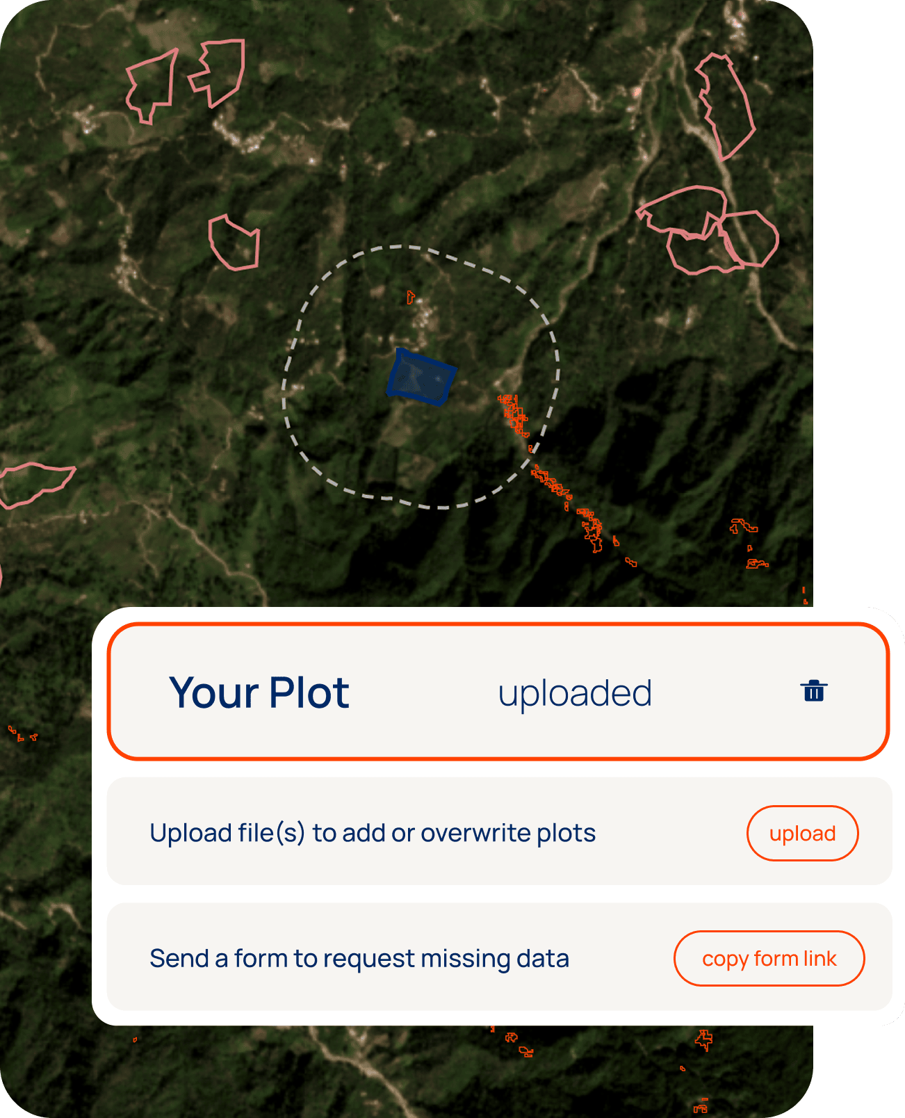
Step 1
Achieve full traceability
Upload plot data directly or invite suppliers to share their plots securely using our streamlined supplier forms. Our system automatically flags errors, applies quick fixes where possible, and provides detailed reports for manual review.
No matter where you are on your traceability journey, our platform logs every submission, helping you work towards 100% traceability—seamlessly. Already using a traceability system? Sync everything via the API while keeping full control over plot uploads and supplier management.
Let us handle the data complexity, so you can focus on driving your sustainable sourcing strategy.
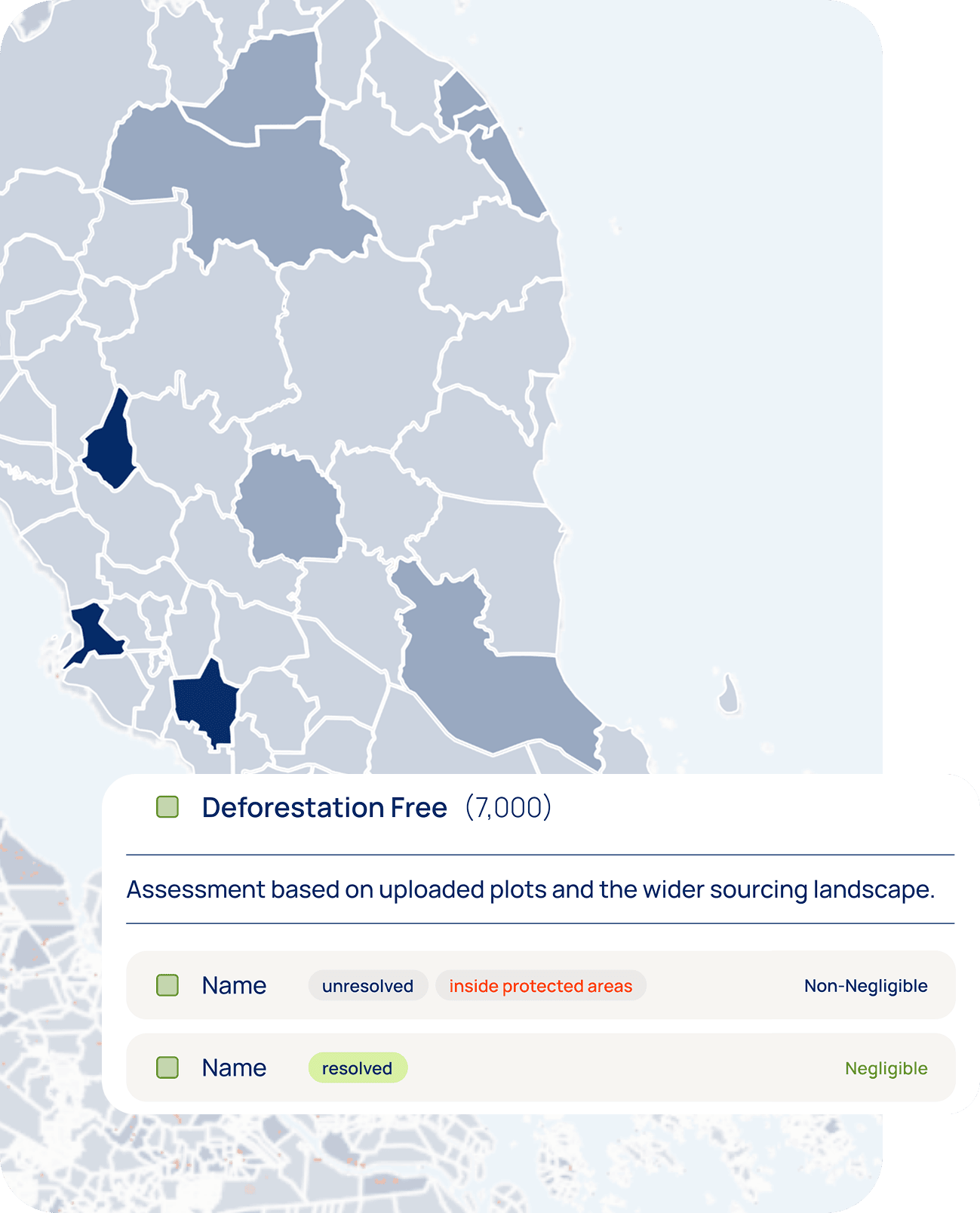
Step 2
Assess deforestation risks - accurately
Don’t let unreliable data create unnecessary supplier headaches. Using low-quality or open- source risk assessment data can lead to false deforestation flags, forcing your sustainability and procurement teams into unnecessary risk mitigation efforts—and straining supplier relationships.
Developed in collaboration with the World Cocoa Foundation and European Forest Institute (EFI), our platform ensures your approach aligns with industry standards—protecting both your sustainability goals and your business relationships.
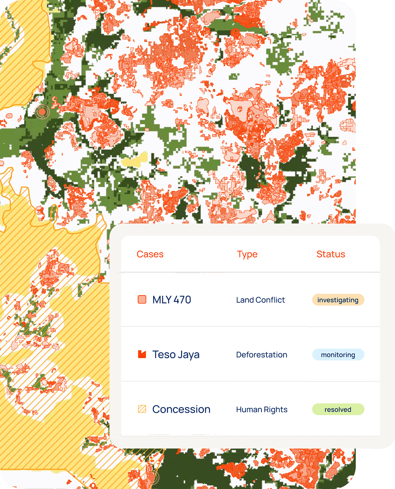
Step 3
Streamline risk mitigation with the case tracker
Ensure compliance with EUDR by efficiently managing high-risk plots and noncompliance in your supply chain. Our Case Tracker allows you to open cases for flagged plots, collaborate with suppliers to investigate and provide evidence, and track every step until resolution.
All cases are securely logged and readily available for audits, demonstrating your real-time monitoring, continuous risk mitigation, and commitment to due diligence. Protect supplier relationships, avoid false accusations, and ensure compliance isn’t just a one-time effort but an ongoing process.
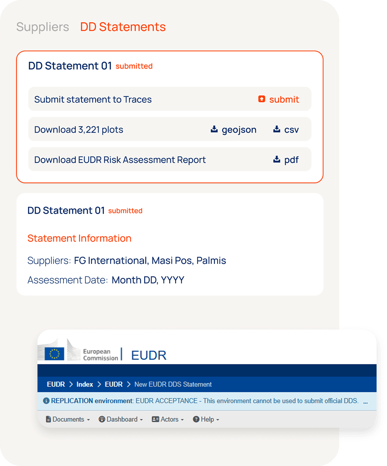
Step 4
Ensure effortless compliance
Submit Due Diligence Statements (DDS) directly to the EU Due Diligence Registry with our built-in API integration. Reuse existing data, invite suppliers to contribute, enter harvest dates, assess risks, and submit—all in one place. By doing it in the same platform where you collect the plots and perform the risk assessment, you forgo the need to build additional traceability capabilities in your IT landscape and you can be sure of a watertight due diligence process.
Need full IT ecosystem integration? Our API keeps suppliers, plots, orders, and risk assessments fully synced, so compliance becomes effortless, not overwhelming.
Your end-to-end solution for
EUDR compliance
Step 1
Achieve full traceability
Upload plot data directly or invite suppliers to share their plots securely using our streamlined supplier forms. Our system automatically flags errors, applies quick fixes where possible, and provides detailed reports for manual review.
No matter where you are on your traceability journey, our platform logs every submission, helping you work towards 100% traceability—seamlessly. Already using a traceability system? Sync everything via the API while keeping full control over plot uploads and supplier management.
Let us handle the data complexity, so you can focus on driving your sustainable sourcing strategy.
Step 2
Assess deforestation risks - accurately
Don’t let unreliable data create unnecessary supplier headaches. Using low-quality or open- source risk assessment data can lead to false deforestation flags, forcing your sustainability and procurement teams into unnecessary risk mitigation efforts—and straining supplier relationships.
Developed in collaboration with the World Cocoa Foundation, European Cocoa Association (ECA), and European Forest Institute (EFI), our platform ensures your approach aligns with industry standards—protecting both your sustainability goals and your business relationships.
Step 3
Streamline risk mitigation with the case tracker
Ensure compliance with EUDR by efficiently managing high-risk plots and noncompliance in your supply chain. Our Case Tracker allows you to open cases for flagged plots, collaborate with suppliers to investigate and provide evidence, and track every step until resolution.
All cases are securely logged and readily available for audits, demonstrating your real-time monitoring, continuous risk mitigation, and commitment to due diligence. Protect supplier relationships, avoid false accusations, and ensure compliance isn’t just a one-time effort but an ongoing process.
Step 4
Ensure effortless compliance
Submit Due Diligence Statements (DDS) directly to the EU Due Diligence Registry with our built-in API integration. Reuse existing data, invite suppliers to contribute, enter harvest dates, assess risks, and submit—all in one place. By doing it in the same platform where you collect the plots and perform the risk assessment, you forgo the need to build additional traceability capabilities in your IT landscape and you can be sure of a watertight due diligence process.
Need full IT ecosystem integration? Our API keeps suppliers, plots, orders, and risk assessments fully synced, so compliance becomes effortless, not overwhelming.
Pricing plans
Choose the right plan based on your business needs.
What our clients have to say

Moving forward, Neste is looking at possibilities to utilize this platform as part of its due diligence and onboarding of new suppliers. This could further strengthen Neste’s risk mitigation measures as part of meeting the requirements of deforestation-free supply chains.''
How we contribute
Discover how our knowledge and expertise support resilient supply chains

Get clear answers to your key
compliance questions
🛰️ Geospatial & Deforestation Monitoring
📦 Data Handling & Platform Capabilities
🔗 Traceability & Supply Chain Data
🛠️ APIs, Integration & Technical Support
🧾 Legal, Roles & Representation