When you think of the world’s leading agricultural driver of deforestation, you may not necessarily think first of coffee. In fact, most would likely picture vast palm oil or cocoa plantations.
But the truth is that coffee plantations have so far been incredibly difficult to map. And if you don’t know where they are, it is rather hard to prove they are deforestation free.
Based entirely on statistical trade models, it is assumed that the European Union alone is responsible for an estimated 30–40% of the embodied deforestation linked to coffee imports – that’s a higher share than for any other commodity covered under the EU Deforestation Regulation (EUDR).
Satelligence insights uncover a complex picture: in some origins, coffee contributes more to deforestation than previously recognised, while in others, shade-grown coffee is wrongly classified as forest, leading to overestimated risk.
The world desperately needs a comprehensive and reliable global map of coffee plantations to understand and mitigate risk.
Insight 1: Risk is higher than previously thought
As the largest global provider of commodity monitoring, Satelligence is often the first to uncover new trends and patterns across supply chains. Our recent analysis compared 200,000 cocoa and coffee farms across an average of 15 countries and revealed something significant: 5.9% of coffee farms show signs of deforestation, 3.7 times higher than cocoa (1.6%).
On a positive note: this also means that most areas are risk-free! You just need to know where they are.
This is also important because we see that campaigning NGOs are significantly ramping up their scrutiny of coffee-driven deforestation, which is usually overshadowed by cattle and oil palm. For instance, Coffee Watch recently highlighted potential non-compliance risks in key sourcing areas for roasters such as JDE Peet’s.
Insight 2: coffee-driven deforestation may be over-estimated
The fact that huge areas of planted coffee are mistaken for forest in widely used maps is fortunately gaining attention. Using such maps, clearing for replanting leads to unfair accusations of deforestation. Without better coffee mapping, future deforestation assessments will lead to wrong results.

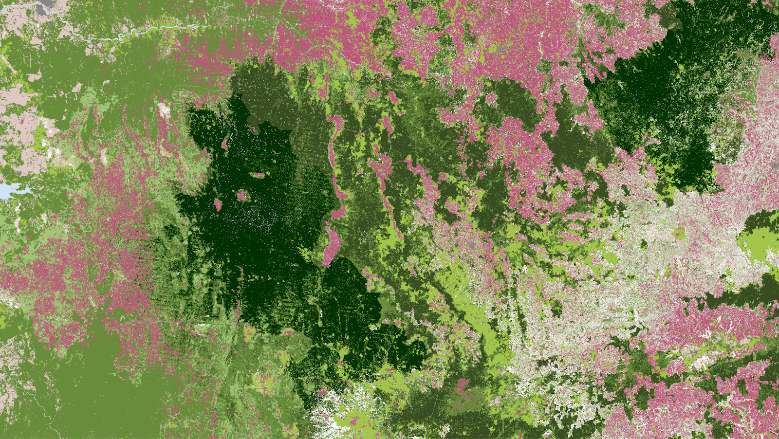
Coffee plantations per country for 6 of the world’s largest coffee producing countries mapped according to highly accurate Satelligence data.
Accurate data drives action
In preparing for the EUDR, many producers and traders resort to tools and software that do not trace supply chains to individual farms or confirm deforestation-free sourcing with reliable forest and coffee data. And you can’t manage what you can’t measure.
This poses great risk to the resilience of coffee supply chains. When coffee-driven deforestation is either over- or underestimated, companies face a higher likelihood of trade disruption and regulatory penalties under the EUDR. Accurate, high-quality maps are therefore essential, not only for compliance, but for making better sourcing decisions that strengthen supply chain resilience. Under the EUDR, as is the case across the full compliance landscape, deforestation data is key to companies achieving their nature and climate commitments.

Comparison between EC JRC open data (right) and Satelligence mapping (left). The Satelligence map distinguishes coffee plantations (red-brown) from forest (green), showing how open data often overestimates forest cover by misclassifying coffee areas.
How to address it
To help protect smallholders and improve supply chain resilience, Satelligence is developing the first global, high-quality, open-access coffee map in partnership with CIAT. When complete, this will be a critical resource for distinguishing between forest, agroforestry systems, and coffee cultivation areas. By integrating CIAT’s Sample Earth dataset, the map will incorporate local ground-truth data to ensure that smallholder coffee plots are accurately identified, avoiding misclassification and data bias.
The resulting map will be publicly accessible, built on a transparent methodology, and designed to give companies, certifiers, and communities confidence in monitoring and reporting their coffee supply chains. The work is underway and we are now engaging partners and supporters to help us complete it. The initial release is anticipated for early 2026.
Why does this matter
The bottom line is: the world needs better coffee mapping to mitigate risk.
From the abovementioned Satelligence insights, it is clear that coffee supply chains need more thorough, precise mapping to ensure that deforestation linked to coffee is accurately identified, that companies are given the best data and opportunities to monitor and rectify deforestation risk in their supply chains, and that smallholder farmers are not left behind. The Satelligence–CIAT Global Coffee Map will serve as a cornerstone for traceable, equitable, and compliant coffee supply chains, empowering millions of smallholders and supporting smooth EUDR compliance across the coffee sector.
About Satelligence
Satelligence is a geospatial sustainability company. Their curated and E&Y verified insights on deforestation, supply chains, land degradation, and downstream scope 3 emissions make product journeys and investment portfolios sustainable, from tree to shelf. They’re trusted by Cargill, Unilever, Mondelez, Bunge, AAK, Rabobank, IKEA, Tony’s Chocolonely, and more.